3.2.1. Create OcTree Mesh Input File
The OcTree mesh used in the DCIP octree code are created using the program create_octree_mesh_dcip.exe. Parameters necessary for defining the OcTree mesh are set in the input file. The lines within the input file are as follows:
Line # |
Parameter |
Descriptions |
|---|---|---|
1 |
min. cell widths in x, y and z for base mesh |
|
2 |
sets the thickness of padding in x, y, down and up directions |
|
3 |
sets cell sizes within core mesh region |
|
4 |
sets thickness of cells of finest discretization near receivers |
|
5 |
the file containing electrode locations |
|
6 |
sets topography |
|
7 |
sets level of discretization for surface topography |
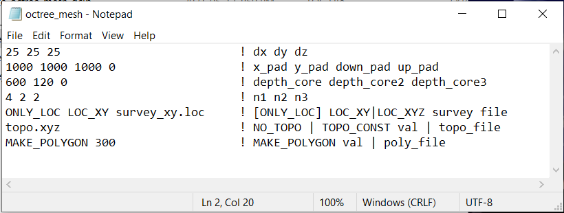
Fig. 3.1 Example input file for creating octree mesh (Download )
3.2.1.1. Line Descriptions
dx dy dz: Minimum cell widths in x, y and z for the base mesh.
x_pad y_pad down_pad up_pad: Distance from the survey area in the x, y, downward and upward directions, respectively, that the mesh extends.
depth_core depth_core2 depth_core3: Sets cell sizes within the core mesh region. Up to a depth of core_depth from surface topography and within a horizontal distance of core_depth from any electrode, the smallest cell size is used (set by dx, dy, dz). Then up to a distance of core_depth2 , the cell widths are 2 times the minimum. The up to a distance of core_depth3 , the cell widths are again increased by a factor of 2. Outside a depth and horizontal distance of core_depth3, the cells widths increase by a factor of 2 for every additional layer (see the figure below).
n1 n2 n3: This sets the thicknesses of layers of finest discretization near the receivers. n1 = 4 means that around each receiver, there is a layer 4 cells thick that uses the finest discretization. This is followed by a layer which is n2 cells thick, where the cell dimensions are increased by a factor of 2. Likewise for the 3rd layer.
locFile: The general syntax is [ONLY_LOC] LOC_XY|LOC_XYZ filepath. This line defines the electrode locations using a survey file or an observations file.
ONLY_LOC: If you are using a survey file, then you must begin this line with the ONLY_LOC flag. If you are using an observations file, this flag is omitted.
LOC_XY|LOC_XYZ:
Use the flag LOC_XY for surface formatted survey files. The code will output a file ‘data_Z.txt’, where elevation columns have been added assuming the electrodes live on the discretize surface topography.
Use the flag LOC_XYZ for general formatted survey files. In the file ‘data_Z.txt’ output by the code, any electrodes that were above the discrete surface topography are projected to the discrete surface. And all other electrodes are left in their original locations.
filepath: This is the filepath to the survey/observations file.
topoFile:
If a topography file is available, the file path to the topography file is entered; see topography file for format.
In the case of flat topography, the user instead enter TOPO_CONST, followed by a space, then the elevation of the surface topography; for example TOPO_CONST 125.5.
If you want all electrodes placed at the top of the mesh with flat topography, use the flag NO_TOPO.
polygon edge width: Here we define the horizontal extent of the core inversion mesh region. The user may do this by providing the path to a file containing the points for a polygon. The user may also set the horizontal extent of the core mesh region based on transmitter and receiver locations. The set of transmitter and receiver locations can be used to create a convex hull. For this option the user types MAKE_POLYGON d, where d is the distance outside the convex hull the user want to extend to core mesh region.